|
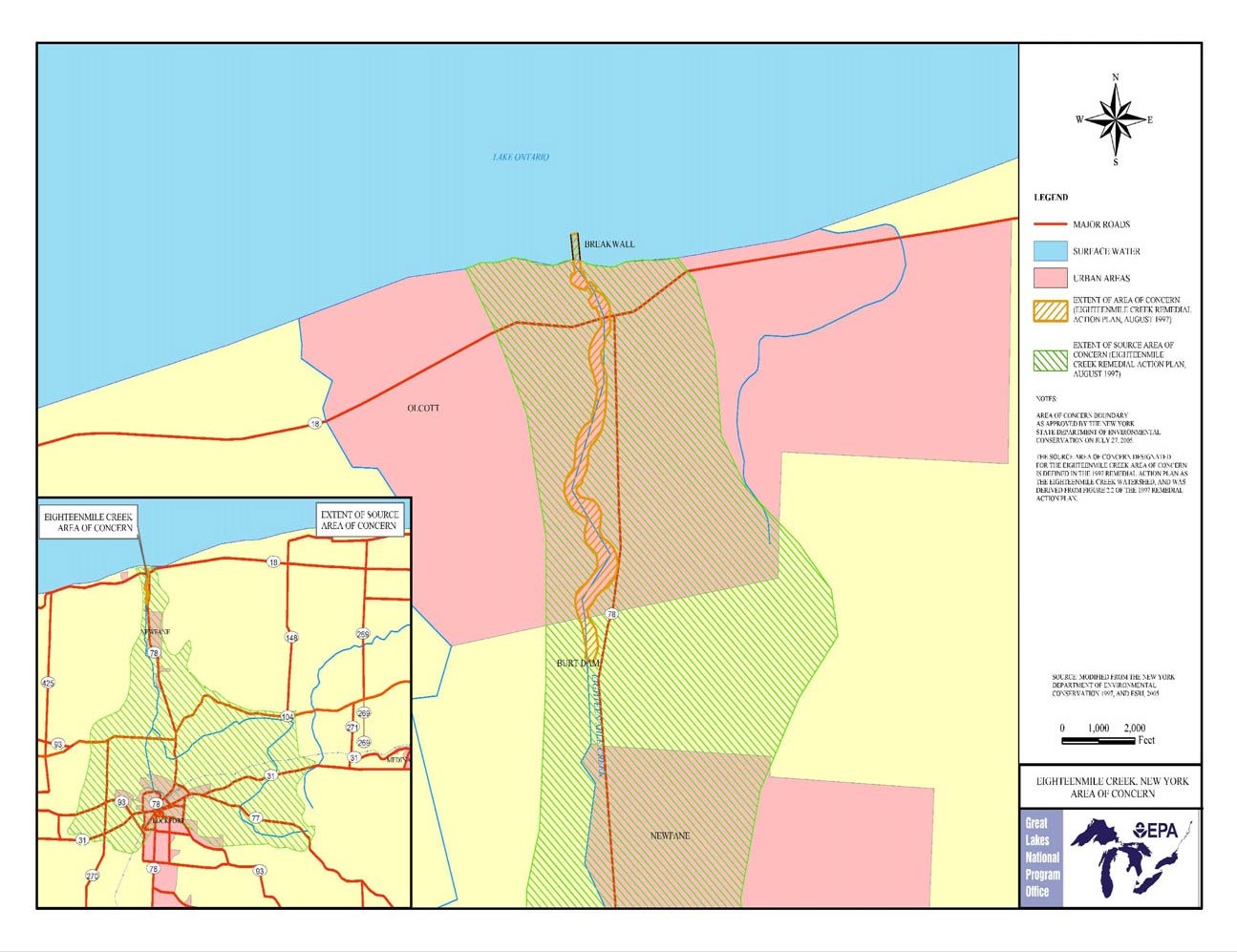
The Eighteenmile Creek watershed is located
along the southern shore of Lake Ontario in
Niagara County, New York. Eighteenmile Creek
flows generally to the north and discharges
into Lake Ontario, through Olcott Harbor,
approximately 18 miles east of the mouth of
the Niagara River. The watershed has a
drainage area of approximately 58,056 acres
and includes Eighteenmile Creek; the two
main tributaries, the East Branch and the
Gulf, and minor tributaries. In addition,
much of the flow in the main branch of
Eighteenmile Creek comes from water diverted
from the New York State Barge Canal.
The natural topography of the area can be
characterized as two relatively flat plains
at different elevations separated by the
Niagara Escarpment. The southernmost portion
of the watershed is at a higher elevation
than the remainder of the watershed and is
separated by the Niagara Escarpment along
the northern portion of the City of
Lockport. The watershed lies entirely within
Niagara County and encompasses portions of
the Towns of Cambria, Lockport (including a
portion of the City of Lockport), Royalton,
Hartland, Newfane, and Wilson. The majority
of the watershed can be characterized as a
rural area comprising agricultural lands,
with scattered residences along roadways,
and rural villages; including Olcott,
Newfane, and Gasport. A portion of one urban
area, the City of Lockport, falls within the
watershed and is the most densely populated
area within the watershed. Commercial and
industrial uses are concentrated in the City
of Lockport.
The main branch of Eighteenmile Creek
originates southeast of the City of
Lockport, in the vicinity of Keck and
Chestnut Ridge Roads, on the south side of
the Niagara Escarpment. It travels northwest
through the city and is diverted underground
near Vine Street, travels north underground
under the Canal to a point near Clinton
Street, where it resurfaces. It continues
generally north, descending approximately
240 feet over the Niagara Escarpment and
flows north through the Town of Newfane
before draining into Lake Ontario at Olcott
Harbor.
A section of Eighteenmile Creek was
designated as an Area of Concern (AOC) by
the International Joint Commission because
of an existing fish consumption advisory,
benthic population decline, a degradation of
fish and wildlife populations, prevalence of
bird and animal deformities or reproductive
problems and restrictions on dredging. Over
the years, numerous contaminants have been
identified in creek sediments which have a
detrimental effect to the AOC and Lake
Ontario. These contaminants include but are
not limited to; Polychlorinated Biphenyls
(PCBs); Mercury; Dioxins and Furans;
Dieldrin; Mirex; DDT; Lead; and Copper.
Sediments contaminated with these substances
have directly contributed to the impairments
just mentioned.
Interestingly enough, the AOC is relatively
pristine to the naked eye. This section of
Eighteenmile Creek flows through a steep
sided, undeveloped wooded gorge, where
habitat disturbances are minimal. The
extensive beds of emergent and submergent
aquatic vegetation in this area account for
an estimated 65 acres, comprising one of the
largest coastal wetlands in the western
portion of Lake Ontario. These wetlands and
undisturbed woodlands bordering Eighteen
Mile Creek provide valuable habitats for
wildlife that are uncommon in Niagara
County's coastal area.
A variety of bird species inhabit the area,
including great blue heron, green-backed
heron, mallard, wood duck, belted
kingfisher, marsh wren, common yellowthroat,
red-winged blackbird, and swamp sparrow..
Eighteen Mile Creek is particularly
significant because large concentrations of
Coho and Chinook salmon and brown trout
migrate from Lake Ontario into the creek
each fall. In addition, steelhead migrate
into Eighteen Mile Creek during the fall and
between late February and April. Due to the
importance of this area, NYSDEC has
determined that, �Disturbances of wetland
vegetation, including submergent beds,
through dredging, filling, or bulkheading
[excluding Olcott Harbor], would result in a
direct loss of valuable habitat area."
The mission of the Eighteenmile Creek
Remedial Action Plan (RAP) is, to restore
the chemical, physical and biological
integrity of the ecosystem in the
Eighteenmile Creek Area of Concern in a
manner that reflects the communities concern
for the preservation and protection of the
waterway. Specific goals of the RAP are the
protection and enhancement of human health,
fish and wildlife, aesthetics, recreation
and the economy of the Eighteenmile Creek
Area of Concern. Bathing and aquatic life
have been established as the best uses of
Eighteenmile Creek through a public process
under the New York State Stream
Classification System. The RAP is designed
to restore these uses where they have been
impaired and to move toward the reduction of
all sources of pollutants.
Due to the cost and extent of
contamination in Eighteenmile Creek, the
NYSDEC requested the Eighteenmile Creek
Sediment Site be nominated to the National
Priorities List (also known as Superfund).
Eighteenmile Creek was placed on the
National Priorities List in 2012, breaking
the site into three different Operable Units
(OU). OU1 includes the relocation of
residents on Water Street and demolition of
the homes as well as the former Flintkote factory.
OU2 includes soil remediation of the Creek
Corridor (several parcels of land in the
City of Lockport between the Barge Canal and
Harwood Street). Lastly, OU3 involves
remediation of approximately 15 miles of
creek sediments from Harwood Street in the City of Lockport, to
Lake Ontario. The RAP has worked very
closely with Superfund to ensure that work
being completed will contribute to both Superfund
and AOC objectives.
DATA
Eighteenmile Creek Comprehensive Watershed
Management Plan
Eighteenmile Creek Remedial Action Plan-
Stage II Update
|